ReedNavigation.com
Classes in celestial navigation and related topics


Easy Lunars
"Lunar Distances" or lunars for short were used to determine longitude at sea in the period from about 1767 until 1850 (and rarely after that date). This was a time when chronometers were not yet widely available at a reasonable price and were considered unreliable on long voyages. The principle behind lunars is simple. The Moon in the sky is the hour hand of a great clock. The stars along its path are the numbers on the face of the clock. If we can measure the Moon's position relative to the stars, we can read the time from the clock. Comparing that absolute time with local time, usually determined by a time sight, we have our longitude. A one hour difference in time corresponds to a 15 degree difference in longitude. I wrote the essay below in 2004. It's getting a bit dusty, and I'll re-write it soon, but the principles and details are all in good shape.
LUNARS ARE EASY
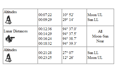
First, you have to get out your sextant and shoot a lunar. I shot a set on April 26, 2004 on Lake Michigan. Since my Plath sextant
had been banged around a bit recently, I started with an index correction
sight. This has to be done very carefully for a lunar sight since you're
trying for fraction of a minute of arc accuracy. My IC was -1.0 minutes.
Next, I shot an altitude of the Moon's Upper Limb above the horizon of our
inland sea and noted the time:
Moon UL: 45°46.8' at 20:09:51 GMT.
Then I shot a very rough altitude of the Sun (no horizon but easy to estimate
from converging lines (Chicago is flat):
Sun LL: 47°49' at 20:11:14 GMT.
And finally one lunar sight (it's best to take four or five and average them or draw a line through them but I didn't have time to spare). The Moon was just shy of half full so I estimated that its elongation from the Sun would be about 75 degrees. I preset the sextant to that angle and aimed at the Moon. The line perpendicular to a line drawn through the Moon's "horns" always points to the Sun, so I rotated the sextant until the Moon appeared "horizontal" in the horizon glass. After a minute or so of sweeping around, I found the Sun. Then I brought the Sun into rough contact with the Moon so that they were touching limb-to-limb. When you're shooting Sun-Moon lunars, you're always bringing the "near" limbs together. From here, it's a slow process of adjustment. I usually lower the sextant from my eye, give the micrometer a slight turn, and then look through it again holding the sides of the frame with both hands. This makes for a stable platform. It also helps to sit while doing all of this. Note that you don't have to adjust the micrometer "live" as you're used to doing with altitude sights since the lunar changes very slowly. Finally, when the limbs were just touching, I noted the distance:
Moon-Sun Near: 80°09.3' at 20:16:37 GMT.
After taking the lunar, I again measured the altitude of the Moon:
Moon UL: 47°13.8' at 20:17:57 GMT.
I didn't bother getting a second altitude for the Sun, but it was probably about a degree and a half lower by this time. Finally, note that my height of eye was close to ten feet, and temperature was 59°F and pressure was 29.93 inches Hg.
Calculating the Geocentric Lunar Distances
With the observations in hand, it's time to get out the Nautical Almanac.
First, there is one long calculation to do so that we have proper geocentric
lunar distances to compare against the observations. This is exactly like
the case of star-star distances except the Moon and the Sun move around much
more rapidly, so we have to calculate two distances bracketing the time of
the observations. In the 19th century, these distances were pre-calculated
in the Nautical Almanac for every three hours of GMT. Today, it may make
more sense to do the calculation for every hour (you can follow the steps
here or you can also get pre-computed distances here on my web site (ReedNavigation.com).
We go to the almanac for April 26, 2004 at 20:00 and 21:00 GMT and dig out
the GHA and Dec for the Sun and the Moon. Then the LD follows from the usual
cosine formula:
LD = arccos[sin(Dec1) · sin(Dec2) + cos(Dec1) · cos(Dec2) · cos(GHA2-GHA1)].
I find:
geocentric_LD = 79°59.1' at 20:00:00 GMT,
geocentric_LD = 80°26.7' at 21:00:00 GMT.
We'll also need the horizontal parallax for the Moon for those hours and
the semidiameter for the Sun on that date. They are:
HP Moon = 54.7, SD Sun = 15.9.
Pre-Clearing the Lunar
Unike a star-star sight, there is a "pre-clearing" step in every lunar. With
stars, you can measure the distance from center-to-center since the star's
image is basically a point. But with lunars, you're always measuring to a
limb. So the first step is to add in the semi-diameter of the Sun and the
Moon (you add for a "Near Limb" lunar and subtract for a "Far Limb"). We've
got the Sun's SD from the almanac. You can take the Moon's SD from there,
too, by interpolating. The listed SDs are correct for noon GMT. It's also
easy to calculate it since it's proportional to the HP:
Moon SD = 0.2724 · HP = 14.9'.
For the Moon, we also need the "augmentation" of the semidiameter. This is the slight increase in the Moon's size when it's overhead (you're closer to the Moon on average when it's high overhead). You can calculate this from 0.3 · sin(H_moon), or you can use this short table:
<10° 0.0'
<30 0.1
<56 0.2
<90 0.3
For the sights above, the augmentation is 0.2' so the Moon's augmented SD
is 15.1 minutes of arc. The sum of the two semidiameters is 31.0 minutes.
That means our center-to-center lunar measurement is:
observed_LD = 80°39.3'.
Clearing the Distance
And now to clear the distance... We need to remove the local, observer-centric
effects of refraction and parallax so that we can compare our measurement
with the predicted geocentric distances above. As in the case of star-star
sights, we clear the altitude by determining very carefully how much each
object's altitude is modified by refraction (and parallax now, too) and then
figure out what percentage of that change in altitude acts along the arc
from one object to the other. For star-star sights, the equation was:
corrected_dist = observed_dist + dh1 · A + dh2 · B
where dh1 and dh2 are the altitude corrections and A and B are the percentages
or "corner cosines" for the arc in question. With lunars, the change in the
Moon's altitude can be as much as a degree. This is large enough compared
to the other angles involved that we need to go one more step in this
calculation. There is a "quadratic" correction, call it Q, that has to be
added into the puzzle. That is, the equation to correct a lunar distance
is:
corrected_LD = observed_LD + dh_Moon · A + dh_Sun · B + Q
where Q is given by
Q = 0.5 · (dh_Moon)² · (1-A²) / tan(dist) / 3438.
and dh_Moon is the Moon's change in altitude. A is the same "corner cosine" factor from above [note: if dh_Moon is measured in minutes of arc and you want the result in minutes of arc, then Q, as indicated, has to be divided by 3438 (the number of minutes in a unit angle)]. This "Q" correction is usually less than a minute of arc, and it is often small enough to be ignored. In the observation I've described above, the measured lunar is about 80 degrees, so the factor cot(dist) is a small number which guarantess that Q is less than 0.1 minutes of arc. Q is also very small when the Moon's altitude is above 60 degrees and when the Moon and the other object are roughly aligned vertically.
The Linear Terms
Let's calculate A and B first. These "corner cosines" tell us how much of
an object's altitude correction acts along the arc that we are measuring.
So, for example, when you're shooting a lunar, if the Moon is exactly above
the Sun or other object (so that their azimuths are identical), then the
A and B factors would both be 100% (though opposite in sign). These factors
are exactly the same as in the case of star-star distances:
A = [sin(H_sun) - cos(dist) · sin(H_moon)] / [cos(H_moon) · sin(dist)],
B = [sin(H_moon) - cos(dist) · sin(H_sun)] / [cos(H_sun) · sin(dist)].
The Altitudes
We've already got the distance, 80°39.3'. We also need the corrected altitudes.
These altitudes do not have to be especially accurate. For the Moon's altitude,
I took one sight before the lunar and one after the lunar. We can interpolate
between those two values to get an altitude that is effectively simultaneous
with the lunar distance observation. You can correct the altitudes for dip
and semidiameter separately but it was common in the 19th century to use
a "cheap" correction that combined these: add 12' for a Lower Limb sight,
subtract 20' for an upper limb sight. Applying the various corrections, I
get:
Sun LL corrected = 47°12'
Moon UL corrected = 46°39.5'
Crunching the numbers on a handheld calculator, the results are:
A = 0.909, B = 0.90.
It's only a coincidence that the values are almost the same in this case.
There's no need to bother writing down more than 3 digits of A and 2 digits
of B. These number are telling us that 90% of the Sun's altitude correction
acts along the arc of the lunar distance and almost 90.9% of the Moon's altitude
correction acts along the arc.
Altitude Corrections from the Almanac
To complete the clearing process, we need accurate values for dh_Moon and
dh_Sun. These are the combined effects of parallax and refraction. And here
we can use the standard tables in the Nautical Almanac. Opening the front
cover of the Nautical Almanac, the altitude correction for the Sun at 47
degrees altitude is -0.8 minutes. This is the average of the corrections
for UL and LL. Opening the back cover of the Nautical Almanac, the altitude
correction for the Moon is 36.5 minutes (again found by taking the average
of the corrections for UL and LL --this is the same procedure that's used
for bubble sextant sights). I also checked the temperature-pressure correction
table in the front of the almanac. The conditions were close to standard,
so there was no additional correction for either object. And there's one
more important step: change the signs on both dh_Moon and dh_Sun. Finally
putting all the pieces together, we get the corrected distance:
corrected_LD = observed_LD + dh_Moon · A + dh_Sun · B + Q
= 80°39.3' - 36.5 · 0.909 + 0.8 · 0.90 + 0 (Q is negligible)
= 80°39.3' - 33.2' + 0.7'
= 80°06.8'.
Interpolating to find the Longitude
At last, we can compare this cleared lunar distance with the predicted geocentric
lunars for 20:00 and 21:00 GMT. They were 79°59.1' and 80°26.7' respectively.
Just eyeballing the numbers, our cleared measurement is about 25% of the
way in between the two predicted distances, so this is telling us that the
time we've measured must be close to 20:15. That's good. Interpolation yields
a time for the lunar of 20:16:44. This is the GMT implied by the measurement.
Since the sight was actually taken at 20:16:37, this means we've determined
GMT to within just 7 seconds. Not bad! In fact, that's probably just a very
lucky sight. If you can determine GMT to within 30 seconds of time, you're
doing well. To convert the difference in time to a difference in longitude,
divide the difference in seconds of time by 4. That is, an 8 second error
in GMT is equivalent to a 2 minute error in longitude.
This Approach in Historical Context
The method for clearing a lunar that I've described here is very similar
to the old methods of Witchell, Mendoza Rios, Bowditch, Thompson and others
which were popular in the 19th century. Those methods depended on logarithms
for their calculation of A and B and they used various trigonometric identities
to put those calculations in a form suitable for logarithms, but that's just
a re-arrangement of terms. There is no fundamental difference. The quadratic
term which I have called "Q" was usually calculated in a special table that
was included in Bowditch, Norie, etc. (table 35 in Norie, for example). The
method I've described above is also very similar to the approach that Letcher
used in his 1978 "Self-Contained Celestial Navigation with H.O. 208". He
chose to calculate refraction instead of using the tables in the Nautical
Almanac. This has some advantages, but also a few disadvantages. Specifically,
that approach is unable to handle the parallax of the Sun, Venus, and Mars
(all of which are included in the tables in the front of the almanac) and
it also cannot handle non-standard temperature and pressure which can easily
amount to a few tenths of a minute of arc difference in the cleared lunar.
I prefer including the complete altitude correction from the almanac since
they can accomodate these various small factors.
Little details to worry about...
The method I've described here does not include a correction for the oblateness
of the Earth. This can be added easily but it's a fairly minor issue. This
method is also prone to error when the lunar distance itself is below 15
degrees or the altitudes of the objects are below 15 degrees, and it should
not be used under those circumstances. This is an intrinsic weakness of any
"series expansion" solution of the lunar distance problem. This method also
does not account for the flattening of the Moon and Sun by refraction when
they are close to the horizon, but this effect is only significant at altitudes
below 20 degrees which are already excluded on other grounds.
© Copyright 2004-2022, Frank Reed, ReedNavigation.com, Conanicut Island USA.